History of Fort Hill, Part 2 (2008). Mural by: Loray McDuffie, Taylor Saintable, Edwin Perez-Clancy, Christine O'Connell, Julia Andreasson, Jorge Benitez, Divah Payne, Lucy Saintcyr, Laua Dedonato, Gregg Bernstein.
Showing posts with label highland park. Show all posts

Wednesday, September 22, 2010

Is it Fort Hill? Or, Highland Park? Perhaps it is the Roxbury Highlands?

This nice map appeared on eeka's blog last year. Quibbling, we would rope in the triangular Veteran's Park at the northeast corner. That yields only five long boundary streets, without that short pesky stretch of Shawmut.

Jonas Prang's focus is on the area of Roxbury bounded by Malcolm X Boulevard, Washington Street, Marcella Street, Ritchie Street, and Columbus Avenue.

Some folk seem to get agitated when the supposedly down-market moniker "Fort Hill" is used instead of the leafy appellation "Highland Park." The exalted epithet "Roxbury Highlands" has some adherents, too.

We think that any of the three names works just fine. And, work they do in different contexts.

Google Maps labels the area Highland Park, unless one zooms in too close.

Drop "Roxbury Highlands" Boston into maps.google and get this.

Do the same with "Fort Hill" Boston and get some other Fort Hill located in Hingham.

The neighborhood organizations seem to split the difference between Hill and Park. So a web site entitled "Highland Park Neighborhood" gives the "Fort Hill Civic Association" as the neighborhood's de facto town meeting, while also listing meeting times for the "Highland Park Neighborhood Assn."

Then, the on-again-off-again Our Highland describes itself as a" one-stop website for everything Highland Park, Roxbury."

For another example, in helping some folk to find housing in Greater Boston, we've been cruising through the Craigslist listings.

At the time we did our search, in boston/cambridge/brookline > housing > apts by owner, there were no apartments in "Highland Park," nor were there any in "Roxbury Highlands."

One is a little luckier with "Fort Hill." There were nine listings.

Alas, of these only five are unique, and only three of these are actually listed by the owner. The four other listings are broker-generated for the same, apparently haplessly unrentable, apartment.

Does this make "Fort Hill" more exclusive than "Mission Hill" with its 23 listings?


[An addendum: Iseut addressed the issue of names for Fort Hill in a post in March. A few other folk weighed in with comments, some more helpful than others.]

Monday, September 20, 2010

Sofrito! Tropical Foods vs. C-Mart

Sofrito!

It's time to prepare a mess of sofrito before winter sets in. Then it goes into everything: black beans, fried white cheese, soup, poached chicken breasts. If it's heated, put some sofrito in it.

There's no need to be picky about proportions, just go with your gut. There's dozens of recipes available on the web, but you don't need to slavishly follow any of them.

What you need are these basic ingredients, plus a blender or food processor, and ice cube trays:

tomatoes
red onions
red peppers (or green peppers or both)
cilantro
garlic


In addition culantro (racao) and ajices dulces (ajicito pepper) are good if you can find them.

Chop things up a bit with the kitchen knife and toss everything in the blender or food processor. Run the blender or food processor, but not so long so that you have a puree. You want to be able to see the individual ingredients.

Then spoon the mixture out into ice cube trays and freeze. Sofrito keeps fresh in the refrigerator for a couple or three days, so if you don't have enough ice cube trays for the whole recipe, freeze the batch a bit at a time.

Once the sofrito is frozen, dump it out into double-bagged Ziplock bags and put the bags in the freezer.

As we've pointed out elsewhere photojournalism is not our specialty and neither is writing about food. So, we had the presence of mind to photograph the end result, but not to photograph the marvelous pile of fresh ingredients at the start of the preparation.

The afternoon we prepared our winter sofrito we needed cilantro, culantro, garlic, and ajices dulces, already having the other ingredients on hand.

So, we took the 41 bus to Dudley and walked in-bound on Washington Street to Tropical Foods, 2101 Washington St.

After looking around and failing to find them, we asked a manager where the culantro and the ajices dulces were. He repeatedly tried to direct us to the cilantro, but we insisted on culantro. The cilantro looked ratty anyway.

Finally the manager (an Anglo as it turned out) told us to ask "that guy—he speaks Spanish."

"That guy" knew right away that culantro was the same things as racao. He pointed us to the mezzanine shelf where both culantro and ajices dulces were available, pre-packaged.

After looking at the garlic ($1.99/lb), we thought we could get better looking garlic at C-Mart (Washington at Herald Street) and we wanted to see if they carried culantro and ajices dulces, so off we went to take the Ridiculous Silver Line to Chinatown.

C-mart didn't have ajices dulces, but they did have culantro, labeled in Chinese characters. The cilantro came in big bushy bundles. The culantro was cheaper at C-Mart; the garlic was cheaper at Tropical Foods. (The best cilantro was at Russo's in Waltham: $1.29 for a big happy-looking bunch.)

So here's the price comparison:


Tropical FoodsC-Mart
Cilantroratty looking$0.79/bunch
Garlic$1.99/lb$2.58/lb
Culantro$12.50/lb$6/lb
Ajicitos$7/lbunavailable

We try to keep this blog focused on its catchment: south of Malcolm X, west of Washington, north of Marcella/Ritchie, and east of Columbus. Since some essentials, like food, lie outside these bounds occasionally we'll stray afield (but, see here and here).

[We're no html jockeys for sure. The table looks fine in Blogspot's Compose and Preview modes, but gets a huge amount of head room when published. The table tag, without the angle brackets, looks like this: table style="background-color: white; width: 276px; height: 211px;" border="1" cellpadding="2" cellspacing="0". Blogspot supplies the width and height parameters.

If anybody sees what's wrong, we'd appreciate a comment .]

Tuesday, September 14, 2010

The Old Sad Dudley Manor on Centre Street

The Board of Regents & Roxbury Community College (RCC) are making their mark in Highland Park.

As the owners of record of 167 Centre Street, the Regents had been leasing out the premises to to long-time tenants, F.I.R.S.T Askia Academy. For many years FIRST Academy held a Christmas Tree sale from the adjacent RCC parking lot. They were decent neighbors, keeping to themselves and keeping the grounds in reasonably good shape.

But some time before February 2010, FIRST Academy pulled up stakes and left. We had first noted that the building was vacant toward the end of February. [The Harvard Street Neighborhood Health Center and The Dimock Center seem to be the only non-aggregating sites on the web that describe FIRST.]

It is a gracious house and we wanted to write about it, but hesitated to bring attention to it when it was vacant and disused.

We needn't have worried.

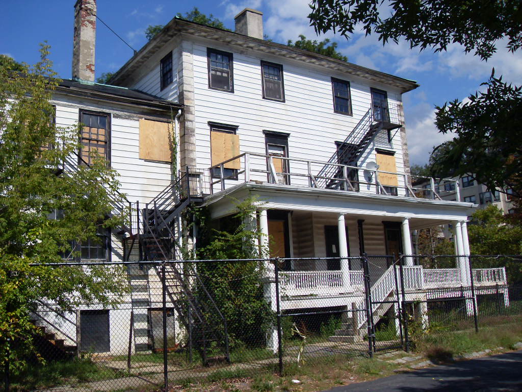
The picture at the beginning of this post is what in-bound commuters on Columbus Avenue see when they look across the parking lot after passing the intersection with Centre Street. The careless, unpainted boards of plywood fairly cry out to those passing by Abandoned! Disused! Vacant! Disinvestment!


We know times are tough for everyone. We're sure that at the time this boarding up was done, it was done with the best intention of securing an important community asset. The plywood, no doubt, seemed a responsible guard against squatting, vandalism, and worse.

And yet, we wish there had been more thought given before these plywood sheets were slapped up. When RCC was being built there was talk of making the Dudley Manor into the president's house. What a grand president's house it would have been. But a "residential treatment program for recovering substance abusers" was a righteous use, too.

At the end of August, City Councillor Rob Consalvo proposed (with Councillors Maureen Feeney and Steve Murphy concurring) an amendment to a city ordinance governing maintenance of foreclosed property. It would have enabled the Inspectional Services Department to require owners of foreclosed property to secure the windows and doors from the inside to make the property look more secure and less offensive. If the City government considers compelling absentee landlords to treat the streetscape with respect, RCC might do well to reconsider how it has defaced the Dudley Manor. [Universal Hub article from ]

This summer RCC undertook a significant program of resetting all the granite coping on its three brick buildings. No doubt there was other work done at the roof line as well that was not obvious from the ground. The community is happy that the college is taking care of its buildings.

But, the old Dudley Manor house should receive at least as much care from RCC as do the new buildings. Perhaps there is a plan for this historic house. It would be nice to learn what it is.

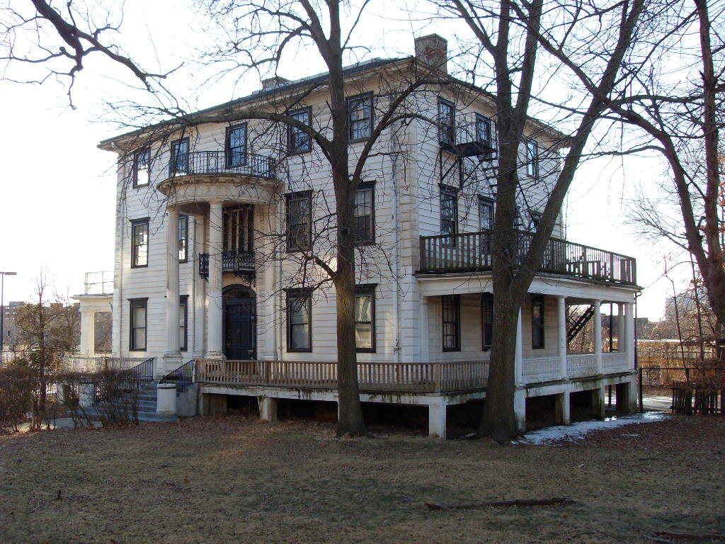
Here is the Dudley Manor on a warm February afternoon before its plywooding.


Curiously, there is very little to be found about the Dudley Manor on the web. Except for the mention on the Harvard Street Neighborhood Health Center site, it is not even clear that the building should be called the Dudley Manor.

Friday, September 10, 2010

A calmed Centre Street

Delightful portulaca flourishing at the switch-back onto Fort Ave.

Over the years the traffic on Centre Street between Eliot and Jackson Squares has calmed down. In the '70s when the street was wider and nobody parked on Centre Street, because nobody could afford a car, through traffic raced across this part of Highland Park at speeds of 35 to 45 mph. Two particularly dangerous spots were the crest of the hill at Linwood Street and the five-way intersection with Cedar St. and the switched-back Fort Ave.

Centre St was quicker to Dudley, North Dorchester, and the Southeast Expressway than going down Columbus Avenue. And, the reverse was true, too.

Over the years the street, which had been made wide for streetcars, was narrowed. Then, after a long, labored campaign with the city, a traffic light was installed to limit the weekly accidents at Cedar St.

Columbus Avenue was rebuilt and its grade raised, and the exciting traffic rotary that was Jackson Square was eliminated. No longer a straight shot directly into Jamaica Plain, Centre St. was bent almost at a right-angle at Highland St to make a perpendicular intersection at Columbus Avenue with Heath Street.

A truck prohibition was placed on Cedar St. (Careful readers will be happy to note that there is no prohibition on elk, but, to the contrary, they are explicitly permitted on Cedar St.)

Eliot Square was reconfigured and traffic lights were installed, further discouraging through traffic.

Then Centre St was repaved and made quieter because heavy trucks and fast-moving cars no longer went rocketing through the pot holes. Except for the short stretch south of Cedar and north of that little stub of New Heath Street, which remained crater-ridden.

But, just this past week even that stretch of Centre St has been repaved, making the road even quieter.

With the tinkering with the lights at Eliot Sq., giving east-bound Roxbury St. priority, and making through Centre St. traffic wait for 30 seconds for a green, it no longer pays to cut through Highland Park.

The next desirable disincentive may be to implement parking restrictions to cut down on the number of Orange Line commuters, Roxbury Community College students, and Friday afternoon Mosque worshipers who use Centre St for subsidized parking.

Perhaps a residents-only restriction from 8 to 10 am Monday through Friday and noon to 2 pm on Friday would do the trick.

It will be important to implement parking restrictions carefully. Most residents make use of on-street parking. Some run small businesses out of their homes and need unrestricted visitor parking.

Tuesday, September 7, 2010

Darryl Settles's Corner Bar & Kitchen finds a landing pad

Darryl Settles's latest venture, Darryl's Corner Bar & Kitchen, has opened on the border between Lower Roxbury and the South End. This is the location of the long-time Boston landmark restaurant, Bob the Chef's, and, most recently, of the Stork Club.

Here is how Mr. Settles describes the core concept behind his establishment: "When we first started working on the Darryl’s Corner Bar & Kitchen concept we knew we wanted to be a Great Bar with a great kitchen as opposed to a Great Restaurant with a great bar. The distinction is important."

In anchoring his establishment around a bar, rather than a restaurant, Mr. Settles asserts that the "Corner Bar has always been an important part of our community, whether as a meeting place for revolutionaries or respite for the working man."

With the gentrification of the South End and Northeastern's salient into Lower Roxbury, it seems revolutionaries are scarce on the ground. (Lucy Parsons, anyone?) With the unemployment rate nearing Great Depression levels in Roxbury, the class of working men and women is getting much smaller, too. Perhaps students and the white collar class will make up for the missing proletariat and revolutionaries.

Despite the conceptual emphasis on the drinks, Darryl's Corner Bar & Kitchen does not neglect the kitchen. Here is a three-page pdf of the menu (sans prices).

Mr. Settles has been working his publicity machinery well. A google search for the bar's name yields a solid 50 hits of press announcements and reviews. The Bay State Banner has published a feature article.

That corner of Columbus Avenue and Northampton Street ("the intersection of friends, food, and music") is a quick 7 minute bicycle ride and a brisk 20 minute walk from Mr. Settles's first choice of location for his bar and restaurant, so residents of Fort Hill have yet another convenient choice for drinks and dinner.

A little more than six months ago, Mr. Settles investigated 85 Centre Street on Fort Hill as a possible location for his bar and restaurant.

Iseut via UniversalHub brought Mr. Settles's Fort Hill designs to our attention, providing the impetus for this blog. The first twelve posts conclude with this coda. Those posts chronicle some of the kerfuffle Mr. Settles's proposal provoked on the Centre Street side of Fort Hill. It is bizarre that these posts, from a infant blog with a grand total of 40 posts, aspiring only to cover a tiny part of a middling city, consistently show up high on the first page of a google search on the words Darryl Settles.

Despite our previous opposition, we are very pleased that Mr. Settles's has found a congenial location for his bar and restaurant. We are sorry that some on Fort Hill were disappointed that that location was not at 85 Centre Street. But, we are confident that Darryl's Corner Bar & Kitchen will flourish "at the intersection of food, friends, and music." (So far, the church at 85 Centre Street has remained a reasonably quiet and considerate neighbor.)

The timing of the opening of Darryl's Corner Bar is auspicious for the jazz festival that Mr. Settles founded ten years ago, The Berklee Beantown Jazz Festival, is set to start next week on 15 September and is to run for the next ten days.

The festival is located on Columbus Avenue between Burke Street and Massachusetts Avenue, right on the front steps of Darryl's Corner Bar. [This image is owned by the Berklee College of Music.]

Friday, September 3, 2010

Powahouse 'Percent For Art 'Competition

What if every building, whether commercial or residential, private or public, were required to erect a work of art where it abuts the public domain? Why not turn our streetscapes into enticing cultural destinations in their own right? [From the Call for Entries]

Sparking a discussion about the state of legally mandated Percent For Art programs in the local construction industry is the impetus behind the "Powahouse %4ART Competition," not to mention the creation of a fine piece of art that will do Kittredge Square proud.

Under the aegis of the Massachusetts College of Art and Design, Placetailor, Inc. has issued a Call for Entries in a design competition for an installation of public art to compliment a three-unit condominium project (floor plans here) to be built on historic Alvah Kittredge Square at the corner of Highland and Linwood Streets.

Placetailor, Inc. is "a design/build company that makes, repairs, and alters urban environments such as streetscapes, workplaces, and rooftops."

One of their recent projects on Fort Hill is the Pratt House, formerly a wreck of a 160-year old gunsmith’s cottage wedged between Dudley and Kenilworth Streets, next to O'Aces Hair Salon. It is now a 750-square-foot, air-tight, super-insulating home. These two pictures were taken during construction in March 2010.

The entry deadline for the "Powahouse %4ART Competition" is 20 September 2010. The Jury members are: Celia Grant, Director of Marketing & Creative at Associated Industries of Massachusetts; Chris McCarthy, community leader of the Kittredge Square revitalization initiative; and Gretchen Schneider, public artist, architect and educator.

Even while the owners of the Alvah Kittredge House are shamefully failing minimally to fulfill their civic responsibilities, it is good to know that other developers are willing to go beyond common expectations to help make flourish the neighborhoods in which they find their profit.

Thursday, September 2, 2010

10,000 expected at Crump Field for Eid Al-Fitr on Friday, 10 Sep 2010


In an email addressed to members of the Highland Park community, the BRA's Muhammad Ali-Salaam has announced a city parking plan for 850 vehicles to accommodate the 10,000 worshipers expected for Eid Al-Fitr on Friday, 10 September 2010, from 7 am to 10 am.

The event is planned for the Jack Crump Memorial Athletic Field [google satellite image] just north of the Madison Park High School. Ali-Salaam informs us that if "the weather doesn't cooperate, then we will pray at the Roxbury Mosque (ISBCC) in shifts."

Five Highland Park and Madison Park streets will be posted as restricted "Special Event No Parking" to provide 230 on-street parking spaces for attendees of the event.

These streets are Malcom X Blvd, Roxbury St, Madison Park Ct., Ruggles St., and Elmwood St.

Lot parking will be available for 320 vehicles in a portion of the Roxbury Community College lot between Cedar and New Heath Sts, in the parking lot behind the Mosque, in the municipal lot adjacent to Ruggles Ct., and in the Blair lot at the east end of Ruggles St. between Washington St. and Harrison Ave.

In addition, 300 garage parking places will be available at the Renaissance Plaza Garage by Ruggles Station.

For those who decide parking might be a problem, Crump Field is a five to ten minute walk from the Ruggles and Roxbury Crossing Orange Line stations and from the Dudley bus station.

Ali-Salaam also says that planning for the event "is being headed by Chuck McAffee, Headmaster of Madison Park, and we are also coordinating with the COB Parks Dept, Boston Police, School Police, and MBTA Police."


[Edited to correct the date.]

Sunday, June 6, 2010

Urban Amenities: Access to Abundant Mass Transit

Fort Hill is blessed with an abundance of mass transit options.

Within easy walking distance are 21 bus lines and 1 rapid transit line. By a rough count there are over 40 bus stops along the Fort Hill roads of Centre, Dudley, Roxbury, Columbus, and Washington streets, plus Malcolm X Blvd, not to mention the 2 rapid transit stations of Roxbury Crossing and Jackson Square, and the bus depot at Dudley Square.

If one is physically able, there is no absolute need to own a car on Fort Hill just for food shopping.

There are two Stop&Shop supermarkets within walking distance, or easy busing distance, at Brigham Circle and on the fringe of Jamaica Plain.

Tropical Foods is located on Washington Street just in-bound from Dudley.

In addition, there are three corner markets on Fort Hill (Juba and Marcella market, and Fernandez III, detailed in these two earlier posts).

If one can stomach riding the Fraudulent Silver Line, then Chinatown beckons. The closest store is Ming's Market (not sure what it is called now) at Washington and East Berkley streets.

Future posts will list the Fort Hill mass transit options in more detail.

Thursday, June 3, 2010

Sharing the Sidewalk with Toddlers

Anonymous called me a name in the comment (to this post) that have I just deleted, not a particularly bad name, but certainly unnecessary to get his point across. The rest of his post was this:

"And if you were hit by a bike while walking in the middle of the bike path, it would be the righteous bike rider's fault, right?"

Which misses the point completely, because I'm actually on the side of rational transportation policy, presumably his side. After all I was sufficiently interested in promoting bicycling to stand there and count them rather than reading a book until my late bus came.

I have been a devoted bicylist—for years. I have consistently commuted in 3°F weather. I have been doored more than once. I have been smashed up onto the hood of a left-turning automobile (whose driver I called a much worse name, you can be sure). I've twisted my front wheel and fork in trolley tracks. I can repack my bearing races and restring a wheel. I'm just not bicycling now.

Pedestrians, bicyclists, and mass transit users are all getting the transportation shaft. Too much of the infrastructure is devoted to a losing game—personal automobiles powered with petroleum products.

The fact that I find I have to disdain a marked pedestrian way in preference to a marked cycling way and the fact that an imprudent bicyclist may ride too fast and collide with me have less to do with where we walk and ride than it condemns the social choices we collectively have made concerning allocation of resources among the various transportation modes.

Forgive me for reposting this picture (from the previous post) which shows the sign directing pedestrians to walk on smooth concrete in a straight line adjacent to six lanes of traffic, and directing bicycles to bumpy macadam in an inefficient undulating path. Forget the lack of appropriateness of each path to the intended users.

Rather focus on the small group of children, toddlers, actually, and their chaperons to the left of the photograph. I wanted to take a better picture of them, but I did not want to agitate the adults by being a stranger photographing their young charges.

Every day, when the weather is clement, approximately two dozen toddlers take a very slow walk along this segment of the Southwest Corridor Park. Sometimes they are pulled along in a wagon, sometimes they walk together holding onto a rope, as a way to keep them safe and well-marshaled.

It is a perfectly natural activity, something we all would applaud. They obviously do not belong on the designated pedestrian sidewalk next to the Columbus Avenue traffic sewer. They obviously belong on the safe way, among the trees and birds. They ought to walk at their accustomed pace, only being careful to keep together and keep on the path.

It ought not be necessary for them to keep to the right, heed bicycle bells, listen for shouts of "ON THE LEFT," or have any awareness of their surroundings.

It is incumbent upon all walkers, wheeled persons (inline skaters, skaterboarders, unicyclists, bicyclists, and everybody) to slow to an appropriate speed, to the point of dismounting if necessary, to ensure these children can enjoy their morning walk without danger.

This is not an optimal situation. Two to three lanes of Columbus Avenue ought to be devoted to human-powered transportation. Those lanes ought to be full to the brim with humans powering their own transportation. The children and other pedestrians ought to be able to enjoy their walkways unmolested.

This is not yet the state of affairs. And, until it is, we have to share the road.


A final note. Adam Gaffin, in his business at UniversalHub, may have to tolerate name-calling in the comments on his site, but I do not. I'm interested in what folk have to say, but I will delete without fail comments that are not polite.

Rush Hour Bicycle Census at Columbus & Cedar

While waiting 22-1/2 minutes on a weekday evening for a #22 bus at the outbound Columbus Avenue and Cedar Street stop, I did an informal bicycle census. [NB: maps.google has the outbound bus stop south of Cedar Street, when it is actually located north by about ten yards.]

I shouldn't have been waiting for that long. I should have had only a four minute wait, but I wound up waiting five times that long. I arrived at the bus stop at 5:18 pm. The next two scheduled buses (5:22 pm & 5:31 pm) did not run. As I waited for the outbound #22, four inbound #22s passed by. When I finally got picked up at 5:40 pm, two #22s were headed outbound in tandem.


So, making lemonade out of MBTA lemons, in the 22-1/2 minutes, I counted the following:
  • 103 bicycles traveling (outbound & inbound) on the Southwest Corridor bike path
  • 1 bicycle traveling outbound in the Columbus Avenue travel lanes
  • 1 recumbent bicycle
  • a mother-daughter pair (two bicycles), the helmeted ten-year-old with pretty pink streamers on her handlebar ends
  • a handful of fixed-wheeled bicycles, but the vast majority of the cyclists looked like every day Joes and Janes riding home after work or school.
About 20% of the bicycle traffic was traveling inbound, the other 80% was headed outbound.

In addition, there were:
  • 2 outbound scooters
  • about 15 pedestrians, equally mixed between inbound and outbound
Of the pedestrians about half were walking on the path marked for bicycles and the other half the sidewalk marked for pedestrians. Were I to regularly walk this route, I too, would be on the bicycle path, for it is farther away from the smelly traffic sewer of Columbus Avenue. I'm sure that would be inconvenient for the righteous bicycle commuters, but I'd still chose to walk as far away from the motorized vehicular traffic as I could.

I'm surprised that there is that much bicycle traffic. I'd noticed that the bicycle traffic in the SW Corridor was much greater than in previous years, but I never expected to count that many bicycles, even at rush hour.

Wednesday, May 12, 2010

ISD Apparently Takes an Interest in Alvah Kittredge's House


The City of Boston Inspectional Services Department (ISD) has apparently taken a recent interest in the Alvah Kittredge House [Previous article].

About two weeks ago fluorescent green caution tape bearing the city seal, ISD's name, and the instruction to keep out, appeared draped across the slap-dash chain link fencing stretched around the house's ramshackle porch.

One might wonder what city regulations are in violation, but it's possibly a shorter task to list the ones not in violation.

Thursday, April 22, 2010

A Blighted Legacy Taunts Alvah Kittredge Square


The annual clean-up of Alvah Kittredge Square is scheduled for this weekend. From 9 to 11 am this Saturday, 24 April 2010, the "neighborhood scrub down" takes place. A sweet little announcement came to the neighborhood email list asking the neighbors to turn out, to bring flowers to plant and ideas for an after-school program, and to shovel around some city-provided mulch.

If there is enough time and willing hands, folk will walk down to Highland Ave and Centre Street to dress up that corner. The email even includes a pretty picture from Roxbury Highland's glory days.

The Friends of AK Park report they have secured commitment of significant funding from several foundations, have received a promise of help from Mayor Menino, and are confident of additional funding for a reconstruction of the park.

That's not all. The Project Review Committee of Highland Park is considering plans for the construction of a new rowhouse, "a landmark green building, producing more clean energy than it consumes" on the square at the corner of Highland and Linwood streets.

But, wait ... there's still more. It seems that the community garden at Alvah Kittredge Square is soon to be upgraded with a water supply, a concrete walk-way, a (wrought-iron!) fence and gate, and division into thirteen garden plots.

It's been a struggle over the years, but with the development of the apartment buildings facing the square, the investment of many owners and renters, the work of Historic Boston with the rowhouses on the square, the community garden, and other efforts, Alvah Kittredge Square has come a long way.
Except for one small detail: Alvah's house.

This poor derelict presides over the square from its address of 10 Linwood Street. It is a wreck and it continues to slide toward destruction right before our eyes. Here is the facade on a recent morning, propped up with scaffolding.


Here are photographs of the rear of the building and of its west side.

Will the scaffolding be sufficient to keep the rotted wood from tumbling onto the sidewalk? Does the blue tarpaulin partially draped over the roof really keep the rain out?

In a photograph from the web site of the National Trust for Historic Preservation, dated July 2004, the Alvah Kittredge House looked like this.
Given the current scandalous neglect, in a very few more years there will be nothing left of this historic treasure to restore.

The Roxbury Action Program (RAP)—whose name adorns the front of the building—owned this house in the '70s, '80s, and '90s. Preoccupied elsewhere in the neighborhood, RAP sat on the house and allowed it to deteriorate like any feckless, absentee landlord. Since that time RAP has pulled up stakes from 10 Linwood Street and has conveyed the property (probably in 1999) to Alexander Leroy who is trustee of something called the Linwood St Realty Trust.

10 Linwood Street is listed with the city as commercial property, assessed at $179,900.00, with an annual property tax of $5,285.46 for fiscal year 2010—plus interest and fees of $271.95, as nothing has been paid against the tax bill this year. See the roller-coaster valuation history at the City of Boston On-line Assessing web site.

Mr. Leroy, and his do-nothing trust, are dreadfully misusing this historic house and the neighborhood in which it sits, just as the Roxbury Action Program did when it was the custodian.

Diligent neighbors can plant flowers and plan gardens, committed owners can invest, build, and renovate, and responsible and successful charities can lend a hand.

But, until Linwood St Realty takes its civic duty seriously, Alvah Kittredge Square will continue to be taunted by the irresponsibility manifested in this wreck.

Or, Alexander Leroy & trust can get out of the way and convey this piece of historic Fort Hill to someone who can do the job.

This status quo is shameful.


An addendum: On page 40 of this Notice of Taking, [1.465KB pdf] the Collector-Treasurer announces that it is his "intention to take for the City of Boston On Tuesday, the Fifteenth day of December, 2009" 10 Linwood Street, among other "parcel(s) of real estate for non-payment, after demand, of the taxes thereon" of $5,975.20.

Tuesday, April 20, 2010

Clean Streets III

Odd-side street sweeping rolled around to Centre Street for a second time this season, but it seemed there was only ticketing and not the towing that Iseut reported on 6 April.

The guys at the DPW have new toys to sweep the streets with. They've been spotted in Jamaica Plain, East Boston, and Roxbury, so perhaps the entire city fleet has been replaced. These photographs were taken at the Highland Street DPW yard.


Here are photographs of the old sweepers.

(Photo credits. Above: Globe Staff Photo / Mark Wilson. Right: Boston Zest)


If you are in search of a hobby, there seems to be a small, but dedicated, group of folk who are interested in street sweeping equipment—like rail-fans, but with rubber tires and rotary brushes.

Here's a list of popular equipment, plus a Flickr street cleaning fan site: Elgin Pelican (always a classic!), Wayne 993, FMC 984, Elgin Streetking, Johnston 4000, Hako Citymaster 1200, FMC Vanguard 3000, Verro City, Mobil M9D, LMV B62, NIMOS Sweepers, TENNANTS, Zamboni, Wayne 2984, Olympia, Wayne Sweeper, Aebi MFH 2200, Athey Mobils* to get you started.

Boston's street sweeping equipment vendor, American Sweeping, seems to favor the classic Elgin Pelican. Here is an encomium to this great machine on the occasion of its 90th anniversary. This is the Elgin Sweeper Company web page.

Friday, April 16, 2010

The Midnight Ride of William Dawes

Every year on Patriots' Day since the 1980s, there has been a celebration in the Roxbury Highlands of William Dawes's 1774 ride from Roxbury to Lexington, bringing notice to the American guerrillas of British infantry movements.

This year, the 380th anniversary of Roxbury's founding, is no exception, with the annual celebration occurring on Monday, April 19, from 8am to 12:30pm.

Discover Roxbury has the details. There is free breakfast, presentation of the Warren I. Brown scholarship, a lecture by the local architects of Donald Stull and David Lee [their corporate web site], and a trolley tour of the neighborhood.

Open, and free to the public, on that day are the Dillaway-Thomas House (183 Roxbury St), the Shirley-Eustis House (33 Shirley St), and the Eliot Burial Ground (Washington St. at Eustis).

The ceremonial equestrian unit, the National Lancers, is providing a couple of horses and a Dawes facsimile for the ceremony in the yard at the First Church, before setting off on this route to Lexington. The National Lancers have a hodgepodge of photographs from 2008 at their Picasa site, starting with this picture (presumably of William Dawes with his dear mother).

Of course, Wikipedia has an article on William Dawes, too. WGBH did a short feature back in 1991. The Fort Hill Civic Association has some pictures of the 2006 festivities half-way down this page. Wicked Local Brookline has this 2008 story. Visit this historic marker the next time you are near Harvard Square. The Paul Revere House website shows the routes of Revere, Dawes, and the British.

And then there is the Jimmy Hatlo They'll Do It Every Time rendition.

Thursday, April 15, 2010

Urban Amenities: The DPW Yard & Salt Shed

Again, this is not precisely what one would immediately consider an urban amenity, but we shouldn't forget the benefits Fort Hill gains by having the Boston Department of Public Works (DPW) yard and salt shed on its southern flank.


Having this mountain of salt nearby, with the resulting stream of snowplow trucks entering and leaving the yard, means that Centre, Dudley, Roxbury, Marcella, and Ritchie streets are the first to be plowed and salted and are kept clear of snow and ice throughout every winter storm. I can't speak for the other arteries in the neighborhood (Highland, Cedar, Thornton, Guild, and Milmont streets), but Centre Street and Marcella and Ritchie streets are kept pretty clean of snow even at the height of a storm.

One can argue about the environmental impact of spewing salt all over city streets so that Boston drivers can continue driving ... well, like Boston drivers ... even as the first flakes fall. One might also consider if the DPW takes sufficient environmental caution with its huge cache of salt. One might ask if creating a hard-pack snow surface would be better than insisting on plowing right down to the blacktop. (Google Seattle salt sand snow for a variety of views on Seattle's recent experience on the subject.)

But, as long as Boston maintains its current snow removal policy, we should be glad the DPW houses this operation in our neighborhood.


However, in a 29 March 2010 letter to the BRA Board of Directors, Councillor Turner addresses the development plans for Jackson Square. In this letter he states that the presence of the DPW yard and salt shed limits the potential for economic development on the Roxbury side of Jackson Square. He relates that DPW officials have been unwilling to even discuss the long-term prospects of moving the operations of the yard and salt shed to another location.

Councillor Turner would rather the DPW relocate its Highland Street yard and salt shed somewhere else so that the real estate could be devoted to economic development in Roxbury.

See this 14 August 2009 article, "Urban Edge proposes new first-phase plans," in the Jamaica Plain Gazette Online for details on the problems siting housing next to the salt shed. The article claims that salt for half the city comes from this shed. Universal Hub has this 2010 photograph of operations at the West Roxbury salt shed [maps.google satellite view] at Millennium Park.

I don't have strong opinions on the matter, but, for as long as they last, I'm happy to enjoy transportation side effects of our neighborhood hosting this DPW operation.

Monday, April 5, 2010

Urban Amenities: Location, location, location

From this prospect behind the Dillaway-Thomas House at the Roxbury Heritage State Park the view encompasses from Back Bay to South Station.

While not perhaps an amenity, per se, Fort Hill's location must be one of its single greatest assets.

Central to the City of Boston, Fort Hill is within easy striking of the entire city, whether on foot, by bicycle, or by mass transit. It is even convenient to drive, if you know the secret parking places closer into the city center.

Walking or bicycling inbound, the Southwest Corridor Park is a green slice through Roxbury and the South End directly into the city. Going southwest, the Corridor leads all the way to the Arboretum.

The Boston Museum of Fine Art, the Gardner Museum, the Fenway and Muddy River, Symphony Hall are all easy bicycling and walking destinations on a bright spring day. Even closer are Malcolm X and Harris Park and the National Center of Afro-American Artists.

These schools are all within walking distance: Northeastern University, Simmons College, Wentworth Institute of Technology, Massachusetts College of Art, Harvard Medical School, Harvard School of Public Health, Massachusetts School of Pharmacy, Emmanuel College, and Wheelock College. (What have I left out?)

Slightly farther away are the the Back Bay and the Charles River Esplanade. In the other direction, Leverett Pond, Jamaica Pond, and the Arboretum are all within easy bicycling and walking distance. Franklin Park and the Franklin Park Zoo are a short distance down Seaver Street.

Even if these destinations seem a little far to walk for our tender American feet, Fort Hill is served by over 40 bus stops, 2 rapid transit stops, and 21 different bus lines.

For those of us who only think in an automotive mode, Fort Hill is close to Storrow Drive, the Mass Pike, and the Southeast Expressway. Route 9 leads the way west to Newton and 128. This means that employment flexibility is maximized as measured by commuting time. In addition to the center city, Andover, Braintree, Waltham, Cambridge, Burlington, and Lexington, are all feasible commutes by car. They have the additional benefit of being reverse commutes, as well.

The next posts will examine the wealth of MBTA options that runs through and adjacent to Fort Hill.

Wednesday, March 31, 2010

Clean Streets II

From April Fools' Day to the end of November, eight months of the year, Boston Department of Public Works street sweepers ply the roads and avenues of Boston and Fort Hill. The day after the end of the March Monsoons, street sweepers were spotted on Centre Street in Roxbury and, during a quick shopping trip, on Centre Street in Jamaica Plain.

Residential sweeping—and enforcement—starts in earnest on Monday. It will be interesting to see whether Boston engages in a paroxysm of towing on Fort Hill as they did last year, or whether this season of street sweeping will be introduced with only a plague of tickets.

Whichever method is chosen, there will be some very surprised and unhappy residents and commuters in the early days of next week.

The DPW publishes its street sweeping schedule from a remarkably obtuse user interface. The Search by Street Name feature, which is what the average user really wants, is grayed out and not yet implemented. Instead one has to either paw through the entire street sweeping schedule of a particular DPW district, assuming one knows what district contains the desired street. The best way to manage this cumbersome list is to use the browser's search (usually Ctrl+F) to find your street .

Otherwise, one must choose an ordinal number (sic, 1st through 5th!) and one or more days of the week. If you choose just a day of the week your query returns no results. This form seems it would be more interesting to DPW personnel than to Peter Parker.

In a nice touch, the Boston DPW provides the street sweeping schedule for the Mass Department of Conservation and Recreation. This information is also available at the DCR's own web site.

Using the same clumsy interface the DPW offers email reminders.

It is hard to know whether to congratulate and encourage Boston for offering this information on the web at all, or whether to wonder how many years it will take for IT in this little corner of www.cityofboston.gov to catch up to industry standards.

Monday, March 29, 2010

Urban Amenities: Clean Streets

The weather warms, the snow is long gone, and folk are out puttering in their yards, beginning the slow preparation for spring. It's not unusual to to be slightly appalled at the urban trash and litter left behind by the receding winter and snow.

The ubiquitous plastic bags, the fast food containers, cigarette packages, wind-blown paper and cardboard, soda cups, and beverage containers, all moldering in a fecund, smelly matrix of decaying leaves.

It is the city, after all, and it's hard to keep on top of things, when the wind howls and the snow sleets against the face. So, when the weather begins to relent, a couple of hours raking, scraping, and sweeping outside, a little industry, and the front of the property is presentable again.

But, what about the back of the property? Do property owners feel responsible for the back of their parcels?

On Roxbury Street, in two cases, the answer seems to be no.

The Louis Prang House and the old firehouse on Centre Street are reasonably well-kempt.

But, these parcels front both Centre Street and Roxbury Street. In contrast to the clean sidewalks on Centre Street, these property owners permit disgusting conditions on Roxbury Street, to the point where the sidewalk isn't really passable.


The City of Boston and the Prang Estates Associates are the responsible owners of 27 and 29 Centre Street. Perhaps as part of their spring cleaning, they will cast an eye on their Roxbury Street frontage and clean their act up.

The Cruz Management Company claims Prang Estates and Prang House as part of their management portfolio. The tidy bit of landscaping depicted at the right is just around the corner from the trash in the three photographs above.

It wouldn't take too much effort for Cruz to extend its perimeter of concern from merely in front of their office entrance to just up Roxbury Street. With our new neighbors in the mosque and the new Ashur Restaurant taking reasonably good care of their property, it would seem to be the neighborly thing to do.

There is one more point: Roxbury Street, from John Eliot Square to Elmwood Street, is heavily parked by commuters. If we don't show respect for our environs, keeping our streets clean, then the commuters won't either. It is a struggle on Gardner Street, with commuters dumping trash out of their vehicles, but the battle, so far, is totally lost on Roxbury Street.